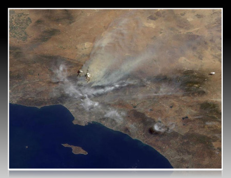
Here’s the latest information on the Station Fire effecting Pasadena, La Canada, Altadena, La Crescenta and Glendale:
- 122,000 acres burned
- 5% contained
- fire lines stretch from La Canada to Acton
- 53 homes destroyed
- threatening 12,000 homes
- two firefighters killed when their truck went off the road
- three residents burned
- crews plan to set backfires Tuesday to protect Sunland and try to halt fire’s northeastern spread by using bulldozers to carve 8 miles of firebreak near Acton
- 4,300 homes under mandatory evacuation – evacuation order (see below)
- estimated fire containment is Sept. 15th
The following evacuation shelters have been established:
La Canada: La Canada High School, 4463 Oak Grove Drive.
La Crescenta: Crescenta Valley High School,2290 Community Ave., La Crescenta.
Santa Clarita: Golden Valley High School, 27051 Robert C. Lee Parkway, Santa Clarita.
Tujunga: Verdugo Hills High School, 10625 Plainview Ave., Tujunga.
Palmdale: Marie Kerr Park, 39700 30th Street West, Palmdale.
- Station Fire, Los Angeles « Flickr Blog – Since erupting August 26th, the Station Fire, burning in southern California, has ravaged more than 140000 acres, killed two firefighters, destroyed more than five dozen homes, and is the largest wildfire in Los Angeles county in over …
- Time Lapse Videos – Station Fire, Angeles National Forest | XSp. – The Station Fire in Los Angeles, California is deemed to be the worst wildfire case in Los Angeles history. Took lots of forest and lots of people’s houses,
- The Best Station Fire Photos – Neatorama – Station Fire photo by Jon Vidar The Big Picture Blog has a roundup of some of the best photos to come out of the Station Fire in Angeles National Forest recently. Over 140000 acres have been consumed by the fire. …
- New NASA Image Shows Extent of Station Fire Burn – Technology … – On September 6, 2009, the Advanced Spaceborne Thermal Emission and Reflection Radiometer (ASTER) instrument on NASA’s Terra satellite captured this simulated natural color image of the Station fire, burning in the San Gabriel Mountains …
- Incredible Time Lapse Videos Of The Station Fire In Los Angeles – Timelapse – Los Angeles Wildfire When a brush fire started near a ranger station in the mountains northeast of Los Angeles on August 26, no one would have guessed that over a week later, smoke would still be spewing over the city. …
|
Photo by Nasa.gov


